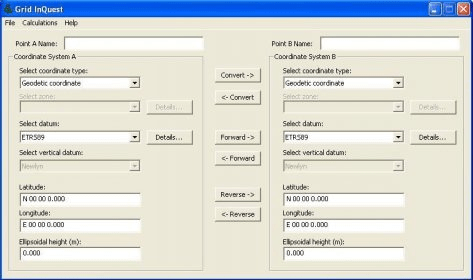
The Grid InQuest software provides a means for transforming coordinates between ETRS89 (WGS84) and the National coordinate systems of Great Britain, Northern Ireland and the Republic of Ireland. It provides a fully three dimensional transformation incorporating the latest geoid model and is the nationally recognised software for performing these conversions.
In conjunction with the Ordnance Survey of Great Britain, the Ordnance Survey of Northern Ireland and the Ordnance Survey of Ireland, Quest provides the Grid InQuest software and associated documentation free of charge for unrestricted use.
The Grid InQuest product uses a DLL containing the actual transformation logic. This DLL is freely available for software developers to integrate into applications, for more information see the programming manual available for download with the software. The DLL is in use by more than 50 companies, including the Ordnance Survey on their www sites as part of their online coordinate transformation services. A Windows Installer Merge Module is available to ease the integration process.


Comments